Tuesday, November 13, 2012

5 Cities on the Same Longitude: Time of Daylight Comparison


            The five cites that I have chosen to compare are Vancouver, British Columbia/ Seattle, Washington/ Portland, Oregon/ Sacramento, California/ and San Francisco, California.


  Vancouver, British Columbia is located 49 degrees and 15 seconds North, and 123 degrees and 6 seconds West. Here, the sunrise was at 7:19 am and the sunset was at 4:35 pm. The low temperature of the day was 43 degrees and the high temperature was 45 degrees Fahrenheit. This is a picture of Vancouver, British Columbia.


  Seattle, Washington is located 47 degrees and 36 inches North, and 122 degrees and 19 seconds West. Here, the sunrise was at approximately 7:11 am and the sunset was at approximately 4:36 pm. The low temperature of the day was 46 degrees and the day’s high temperature was 53 degrees Fahrenheit. This is a picture of Seattle, Washington.


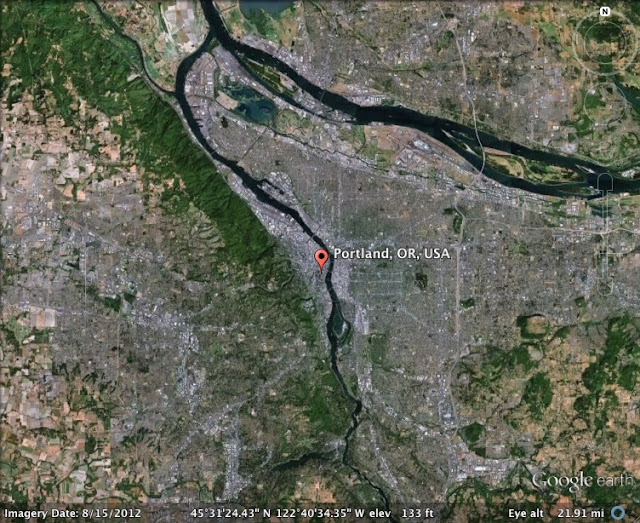
  Portland, Oregon is located 45 degrees and 31 seconds North, and 123 degrees West. Here, the sunrise occurred at approximately 7:06 am and the sunset occurred at approximately 4:43 pm. The low temperature for the day was 46 degrees and the high temperature was 52 degrees Fahrenheit. This is a picture of Portland, Oregon.


Sacramento, California is located 38 degrees and 33 seconds North, and 121 degrees and 28 seconds West. Here, the sun rose at approximately 6:45 am and the sun set at approximately 4:55 pm. The low temperature for the day was 40 degrees and the high temperature was 63 degrees Fahrenheit. This is a picture of Sacramento, California.


  San Francisco, California is located 37 degrees and 46 seconds North, and 122 degrees and 25 seconds West. Here, the sunrise occurred at approximately 6:47 am and the sunset occurred at approximately 5 pm. The low for the day was 49 degrees and the high was 64 degrees Fahrenheit. Below is a picture of San Francisco, California.
            

Monday, November 5, 2012


LOCATION OF THE SUN

Today I documented the location of where I thought the sun was in the sky in Macon, Georgia (November 5th 2012). I have also developed a table that tracks the Time of Day, Temperature, Humidity, Dew Point, and Weather Conditions for the day.

Time
Temperature
(*F)
Relative Humidity    (%)
Dew Point (*F)
Weather Condition
7:00 AM
41*F
93%
38%
Sunny
10:00 AM
56*F
62%
38%
Sunny
12:30 PM
67*F
42%
39%
Sunny
3:00 PM
68*F
38%
39%
Party Cloudy
5:50 PM
59*F
52%
40%
Full Could Cover


THE MAKINGS OF A BAROMETER

In class we made our own homemade barometers. Here is how we did it.
You need:

·      A glass jar
·      A balloon
·      Scissors
·      A drinking straw
·      And tape

Directions: Cut the balloon in half. Stretch the top half of the balloon over the opening of the jar. This step may take time. Make sure the balloon is fully stretched and there is no sag in the middle of the balloon. Next tape the sides of the balloon to the sides of the jar. This step might require a partner. Next, cut the end of the straw to a point (this helps give your barometer more accuracy). Tape the opposite end of the straw to the middle of the balloon so that the pointed end of the straw is hanging off of the balloon. You have now made your homemade barometer.

When the pressure on the outside of the barometer is greater than the pressure on the inside it will push the balloon down and cause the straw reading to elevate. On the flip side, if the pressure on the inside of the barometer is more than the pressure on the outside then the pressure on the inside will make the balloon rise upward causing the straw reading to decrease.

Here are two videos that do a good job explaining the steps:


Sunday, November 4, 2012


Hurricane Chronicle: Katrina
            When someone says the word hurricane, Katrina is the hurricane that always comes to mind. Katrina was the deadliest hurricane of the 2005 Atlantic hurricane season killing 1,833 people total. It was also the most destructive; Katrina was the costliest natural disaster as well as one of the five deadliest hurricanes in the History of the United States. The shear devastation and chaos that it caused will remain engraved in United States history for centuries to come.
Hurricane Katrina formed August 23, 2005 as a tropical depression over the southeastern Bahamas. Katrina strengthened to a tropical storm the morning after it was formed and hit the southern part of Florida categorized as a hurricane. After Florida, Katrina rapidly intensified because of the warm waters in the Gulf of Mexico and in just 9 short hours strengthened from a category 3 hurricane to a category 5 hurricane. Katrina made landfall as a category 3 hurricane with sustained wind speeds exceeding 100 mph. The storm brought huge storm surges, which was the reason of the death of many Louisianans. Katrina has been the most memorable hurricane in my lifetime.

Here are some eye-opening photos of Katrina:


The destruction of Hurricane Katrina affected thousands. Thanks to the National Guard who provided hope in Americas time of need.